
Old Northwest Territory Maps, vintage Great Lakes maps. Historic maps & online map collections of the U.S. Great Lakes region free online.
Table of contents
In addition to the historical maps, there are modern maps showing American Indian lands, plus links to large online map collections that contain more maps of this region.
Collections of Historical Maps
Early Maps of Ohio and the West
Baldwin, Charles Candee
Cleveland, Western Reserve and Northern Ohio Historical Society 1875
1875 article and catalog of existing maps of the Great Lakes region.
Discovery and Exploration
Library of Congress
Various publishers and years of publication
More than 100 historic maps, most reflecting the European Age of Discoveries in North America, from the late 15th to the 17th centuries. Included are 18th and 19th century maps documenting the exploration of the interior of the continent, such as the Lewis and Clark expedition.
Old Maps Online
This is a collaborative portal for accessing a number of online map collections worldwide. U.S. collections include;
The David Rumsey Collection
Harvard Library Collection
New York Public Library Collection
Leventhal Map Center at Boston Public Library
North Carolina Digital Heritage Center
France in America
Library of Congress
Various publishers and years of publication
More than 100 maps from the French colonial era in North America, many of which portray the Great Lakes region.
Individual Historical Maps
Louisiana (French North America)
Wisconsin Historical Society
Vincenzo Coronelli 1695
This is one of the more important and well-known maps of North America from the 17th century. Coronelli used reports of early explorers in the Great Lakes area to create one of the earliest detailed maps of that region. Although Coronelli was a well-known cartographer in his time, his work was often dismissed after his death. It was centuries later that historians rediscovered his work and have shown him to have been an influential figure in his day. (Description from Website). Old maps of the Great Lakes.
Bowles Map
Darlington Digital Library
Hand-drawn 1755
Copy of a 1755 map of frontier areas west of the Appalachian Mountains.
See our Century Past collected links to free online map sites. We have 5 pages of links: for the U.S., North America, UK & Ireland, Worldwide, & Military maps.
Map of the Ohio River Valley and surrounding area
Darlington Digital Library
London: Thomas Jeffries 1755
– Vintage Great Lakes Maps
A map of the British and French settlements in North America
Library of Congress American Memory
John Lodge 175?
Covers the eastern half of North America from Hudson Bay to the Gulf of Mexico. Shows boundaries, cities and towns, forts, Indian villages and tribal territory, and “Earl Granville’s Property.” Vintage Great Lakes Maps
North America
Darlington Digital Library
London: Thomas Jefferys 1755
North America: from the French of Mr. d’Anville, improved with the back settlements of Virginia and course of Ohio, illustrated with geographical and historical remarks. Includes text on the “French incroachments” and “English title to their settlements on the continent”. (Description from website). Great Lakes historical maps.
ancient world history textbook pdf here at Century Past
A New and Accurate Map of the English Empire in North America Representing their Rightful Claim as Confirm’d by Charters, and the Formal Surrender of their Indian Friends, likewise the Encroachments of the French, with the Several Forts they have Unjustly Erected Therein
Indiana Historical Society Collections
London: Herbert & Sayer. 1755
– Vintage Great Lakes Maps.
“Amerique Septentrionale avec les Routes, Distances en miles, Limites et Etablissements”
Alabama Maps Collection
John Mitchell 1756
Mitchell map of British and French dominions in North America. Historical Maps of the Great Lakes.
Recipe book pdf free download here at Century Past
An Accurate Map of the Present Seat of War, Between Great Britain and Her Colonies in North America
Indiana Historical Society Collections
London: Herbert & Sayer 1776
Old Northwest Map.
[Northeastern part of North America]
NYPL Digital Gallery
France: Robert de Vaugondy 1783?
Old Northwest Map.
A Map of the Back Settlements
University of Illinois at Urbana-Champaign: Library
London: Stockdale 1794
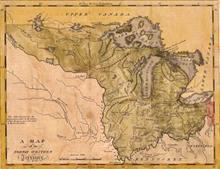
The area of coverage is the Old Northwest. Old Northwest Territory Map
A Map of the North Western Territory
University of Illinois at Urbana-Champaign: Library
Boston: Hill. 1796
Great Lakes historical maps.
See our webpage of historical romance novels online free
A new map of part of the United States of North America exhibiting the Western Territory, Kentucky, Pennsylvania, Maryland, Virginia &c., also the Lakes Superior, Michigan, Huron, Ontario & Erie, with upper and lower Canada &c
Indiana Historical Society Collections
London: J. Cary. 1805
Vintage Great Lakes map.
Map of the Seat of War in North America
David Rumsey Collection
Philadelphia: Melish 1813
Covers from Labrador to Michigan and Ohio.
Upper Territories of the United States
Wisconsin Historical Society
Philadelphia: Kneass & Delleker
The Northwest Ordinance of 1787 provided that one or two states should be created from the area west of Lake Michigan and extending down to the the lake’s southern tip–the “upper territories” shown on this map. That would have placed Wisconsin’s boundary 90 miles further south than it is now. When Illinois became a state in 1818, it wanted access to the lake and managed to have its boundary moved north, depriving the future state of Wisconsin of the city of Chicago. (description from website).
Map of the States of Indiana, and Ohio, with Part of Michigan Territory, ca. 1820s
Lewis University Historic Maps
London: Hinton & Sinupkin & Marshall 1820s
Map of the States of Ohio, Indiana & Illinois and Part of Michigan Territory
Philadelphia: Finley 1827
High-resolution image of a well-preserved color map.
Western States & Territories – Old Northwest Territory Maps
Wisconsin Historical Society
Philadelphia: J.H. Young 1832
Historic Great Lakes maps.
Guide through Ohio, Michigan, Indiana, Illinois, Missouri, Wisconsin & Iowa: showing the township lines of the United States surveys, location of cities, towns, villages, post hamlets, canals, rail and stage roads
Wisconsin Historical Society
NY: Smith, John Calvin 1839
This lovely hand-colored map was removed from J.H. Colton’s Western Tourist and Emigrant’s Guide (New York, 1839). Inset tables list steamboat routes and distances by water, and a vignette of Maidens Rock, on Lake Pepin, appears near the lower margin. This copy retains its elaborate printed border; boundaries and regions are highlighted with water-color. (Description from website).
Read novels online for free no download at our Fiction section
Map of the Western States
Wisconsin Historical Society
NY: Atwood, John M. 1849
This map graphically displays the contrasting degrees of settlement in the states and territories of the Old Northwest.
Local newspaper archives online here at Century Past
Map of the La Crosse and Milwaukee Rail Road and Connections
Collection
NY: Colton, J.H. 1855
Map of the northeastern and north-central United States indicating major drainage, larger cities, state boundaries, and the railroad network.
American Indians and Alaska Natives in the United States
American Indians and Alaska Natives in Alaska
U.S. Census Bureau
U.S. Census Bureau 2011
These two large maps, produced by the U.S. Census Bureau from 2010 census data, show the location of American Indian lands throughout the U.S. The first link shows the 48 states, and the second is for Alaska only. Inset charts show the populations of the ten largest tribal groupings.
Sanborn Maps at Library of Congress
The Sanborn maps are extremely detailed maps of cities and villages produced by the Sanborn Company for use by fire insurance agents in the late 19th and early 20th centuries. The maps are at a scale of 50-feet to one-inch. Some of the maps for the largest cities in the U.S. were over 100 pages. Maps show individual buildings, the construction materials used, and the purpose of the building. Sometimes the company name is included for business buildings.
This Library of Congress free online collection has over 35,000 online Sanborn maps for thousands of U.S. cities and villages. Many towns have more than one map produced over several decades. When searching for a town in Advanced Search, choose a state first to see the complete list of cities in that state. See “About this Collection” (at the Sanborn page) for a full explanation of the symbols and conventions used in the maps.
Historical Atlases
The Ohio and Mississippi Pilot consisting of a set of charts of those rivers
representing their channels, islands, ripples, rapids, shoals, bars, rocks, &c accompanied with directions for the use of navigators,to which is added a Geography of the States and Territories west and south of the Allegheny Mountains
Gilleland, J.C.
Pittsburg: Patterson & Lambdin 1820
Early Maps of the Ohio Valley : a Selection of Maps, Plans, and Views Made by Indians and Colonials from 1673 to 1783
Brown, Lloyd A., comp.
Pittsburgh: University of Pittsburgh Press 1959
This contains descriptions of and information about over 50 early maps, but does not contain copies of the maps.
Related Resources on Century Past
See our Century Past directories for hundreds of webpages of Great Lakes States Resources; Magazines; Books; Articles, Maps & Photos; & Newspapers. You’ll find the same directories on the top Menu. Here are a few suggested pages: