Historic directories and gazetteers for Waukesha County, Wisconsin. Old Maps from Waukesha Co. and City of Muskego. 19th and early 20th Centuries.
Table of contents
For online books, articles and censuses related to Muskego, see Muskego, Wisconsin Local History
Old Muskego and Waukesha County Maps
Map of East Half of Waukesha County, Wisconsin, including Muskego, 1830s
Madison: Wisconsin Historical Society
Increase Lapham
Hand-drawn map created by Wisconsin scientist and geographer Increase Lapham.
See the Menu at the top of every page for Directories of Free Online Fiction and NonFiction Books, Magazines, and more, on 400 pages like this at Century Past
Map of Muskego & neighboring townships in Waukesha County, Wisconsin 1859
UW-Milwaukee Libraries
NY: M. H. Tyler 1859
Sheet 4 in 4-sheet set of maps covering Waukesha County. Note the small map of Plattsburg (later the village of Muskego) to the right of Muskego township.
Century Past has a huge collection of free online books and articles about Wisconsin, past and present. You can start at Wisconsin History
Try our free newspaper archives on Century Past
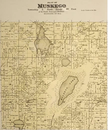
Map of Muskego in Plat Book of Waukesha County 1922
Wisconsin Historical Society
Rockford, IL: W.W. Hixson & Co. 1922
Waukesha County Directories & Gazetteers
Waukesha County Gazetteer and Farmers’ and Land Owners’ Directory, 1890-91
villages, post offices, and settlements, together with a description of the lakes, water courses, prairies, and public localities, in the state of Wisconsin, alphabetically arranged
United States Central Publishing Co. 1890-91
Contains a listing of residents of Muskego Center on page 302, and a “Directory of the Farmers and Land Owners of Waukesha County” on pages 400-576.
Wright’s Directory of Waukesha 1899 …
together with a complete directory of Waukesha County, an alphabetically arranged list of business firms and private citizens; a classified list of all trades, professions and pursuits; a miscellaneous directory of village and county officers; the public and private schools, churches, banks, societies, etc.
Milwaukee: Wright, A. G. 1899
“Residents of Waukesha County giving acreage, section, township and Post Office”, on pages 197-289.
Find a High school American history textbooks pdf at Century Past
Wright’s directory of Waukesha 1909-10 … – Waukesha Historic Directories
together with a Complete Directory of Waukesha County comprising an alphabetically arranged list of business firms and private citizens; a numerical street directory; a classified list of all trades, professions and pursuits; a miscellaneous directory of villages and county officers, the public and private schools, banks, churches, societies, etc.
Milwaukee: Wright Directory Co. 1909
A short list of residents of the village of Muskego appears on page 282. There is a “Farmer’s List” on pages 318-388 covering the entire county.
Wright’s Waukesha Directory 1921 … – Waukesha Historic Directories
containing an Alphabetically arranged list of Business Firms and Private Citizens … a street directory, a miscellaneous directory of county officers, public, private schools, churches, banks, secret and benevolent societies, etc; a farmer’s directory of Waukesha County alphabetically arranged, a “buyers’ guide” and a complete classified business directory
Milwaukee: Wright Directory Co. 1921
Contains a “Farmers List” on page 375 covering the entire county.

