Explore the fascinating history of cartography and the power of maps. Discover articles and videos about early mapmaking, historical mapping projects, and how maps shape our understanding of the world.
Table of contents
The Power and Purpose of Maps
The Mapmaker’s Craft: A History of Cartography at CIA
Tracing its roots to October 1941, CIA’s Cartography Center has a long, proud history of service to the Intelligence Community (IC) and continues to respond to a variety of finished intelligence map requirements. The mission of the Cartography Center is to provide a full range of maps, geographic analysis, and research in support of the Agency, the White House, senior policymakers, and the IC at large. Its chief objectives are to analyze geospatial information, extract intelligence-related geodata, and present the information visually in creative and effective ways for maximum understanding by intelligence consumers.
Central Intelligence Agency 2016
More than a map: the Ordnance Survey’s huge but hidden cultural impact
The Ordnance Survey in nineteenth-century Ireland had a huge cultural influence on not just the Gaelic and Anglo-Irish Revivals but also Synge, Joyce and Beckett.
Coilin Parsons, The Irish Times 2016
Why maps are essential tools for understanding history
historicmusingsblog
Historical Cartography and Mapping Projects
Recently Opened Series: German World War II Maps
“This series contains German maps that display the locations of the Allied armies at different times in 1944 and 1945. The maps include information on various Allied unit locations and the situations the Axis armies were facing at that time.”
The Unwritten Record, National Archives, 2017
Samuel de Champlain’s General Maps of New France
“In the fall of 1612, Samuel de Champlain had an engraving of his first detailed map of New France made in Paris. The map contained new geographic information, based on his own explorations from 1603 onward.”
Library and Archives Canada Blog 2013
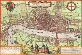
The Forbidden City to Convict’s Landing: rare early city maps- in pictures
From London when it had only one bridge, to a pictorial rendition of Sir Francis Drake’s invasion of Santo Domingo, these global city maps date back to the 1500s and are taken from Great City Maps, published by DK.
The Guardian 2016
World’s First Geologic Map Was Far Ahead of Its Time
A map drawn on papyrus more than 3,000 years ago helped spur the search for mineral wealth in modern Egypt.
Peter Hessler, National Geographic 2016
Maps and Modern Understanding
Europe’s Many Alliances, reimagined as a metro system
Illustrating the many ways that European countries are bound together.
Weiyi Cai, Laris Karklis etc., Washington Post 2016
A Map of Every Building in America
On this page you will find maps showing almost every building in the United States.
Tim Wallace et al, NY Times, 2018
Six maps that show the anatomy of America’s vast infrastructure
“Donald Trump’s plan to invest about $550 billion in new infrastructure projects across the country was a central theme in his campaign. The maps you are about to see show the massive scope of America’s infrastructure using data from OpenStreetMap and various government sources. They provide a glimpse into where that half-trillion dollars may be invested.”
Tim Meko, Washington Post 2016
The Library of Congress Is Putting Its Map Collection on the Map
A new partnership with the Digital Public Library of America will put three major LOC map collections online
Danny Lewis, Smithsonian 2016
Cartography History Videos
Webinars from the Library of Congress Geography and Map Division
LOC Geography and Map Division, Washington, D.C.
Six webinars by employees of the LOC Geography and Map Division. Titles: “Geography and Map Orientation” “Geography & Map Orientation: Fire Insurance Maps” “Introduction to Geospatial Resources” “Maps in the Classroom” “Using Maps in Genealogical Research” “The Boundaries of Afghanistan During the Great Game”.
Geographers on Film
LOC Geography and Map Division, Washington, D.C.
28 video interviews with geographers.
LOC Geography Event Videos
LOC Geography and Map Division, Washington, D.C.
63 Event Videos (2005-2024). Most are videos of speakers at LOC events, on a variety of topics related to maps and cartography.
Explore More Free Online Resources
See our Century Past directories for hundreds of webpages of Books; Magazines; Articles, maps, & photos; and Newspapers. You’ll find the same directories on the top Menu. Here are a few suggested pages: