Explore a vast selection of free online historical map collections of North America and Canada. From early exploration and colonial maps to later periods and specialized charts, discover the changing geography of the continent through these valuable historical resources.
Table of contents
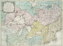
Early Exploration & Colonial North American Maps
American Revolution and Its Era: Maps and Charts of North America and the West Indies, 1750 to 1789
More than 1,400 maps at the Library of Congress. This collection represents an important historical record of the mapping of North America and the Caribbean.
American Revolutionary War-Era Maps
About 2,200 maps from the late 18th century; mostly of locations in North America. Norman B. Leventhal Map Center
Discovery and Exploration
More than 200 maps at the Library of Congress. “Many of these maps reflect the European Age of Discoveries, dating from the late 15th century to the 17th century, when Europeans were concerned primarily with determining the outline of the continents as they explored and mapped the coastal areas and the major waterways. Also included are 18th and 19th century maps documenting the exploration and mapping of the interior parts of the continents, reflecting the work of Lewis and Clark and subsequent government explorers and surveyors.” – LOC “About this Collection”.
France in America
About 650 maps at the Library of Congress. The collection explores the history of the French presence in America from the first decades of the 16th century to the end of the 19th century.
North American and Europe; 17th through 19th Centuries
This collection of about 250 maps is from Colonial Williamsburg.
Pugsley Collection of Early Canadian Maps
50 early Canadian maps; 1556 to 1857, telling story of the discovery and exploration of North America. McGill Univ.
Historical Maps of Canada
Canada Maps to 1800
138 Maps from the Beinecke Library at Yale University.
Canadian Fire Insurance Plans
28 sets, nearly all for towns in Ontario. These are extremely detailed, showing every building. McMaster University Library.
Pugsley Collection of Early Canadian Maps
50 early Canadian maps; 1556 to 1857, telling story of the discovery and exploration of North America. McGill Univ.
Later & Comprehensive North American Map Collections
Charting America: Maps from the Lawrence H. Slaughter Collection and Others
Nearly 4,000 items, at the New York Public Library. Groups include: Atlases and Gazetteers; Maps of the Oceans; Maps of North America; Maps of New York City and State; Charts and Maps.
Historic Road Maps
20th century maps for auto travel for the U.S., Canada and Mexico, and some in Latin America. Perry-Castaneda collection.
Discovery and Exploration
More than 200 maps at the Library of Congress. “Many of these maps reflect the European Age of Discoveries, dating from the late 15th century to the 17th century, when Europeans were concerned primarily with determining the outline of the continents as they explored and mapped the coastal areas and the major waterways. Also included are 18th and 19th century maps documenting the exploration and mapping of the interior parts of the continents, reflecting the work of Lewis and Clark and subsequent government explorers and surveyors.” – LOC “About this Collection”.
Explore More Free Online Resources
See our Century Past directories for hundreds of webpages of Books; Magazines; Articles, maps, & photos; and Newspapers. You’ll find the same directories on the top Menu. Here are a few suggested pages: